Hattusa: The Lost Capital of the Hittite Empire
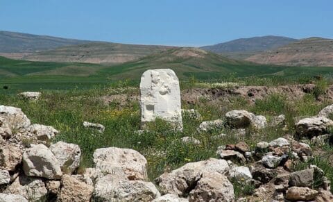
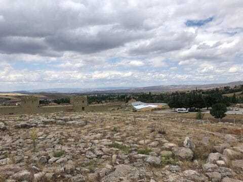
Hattusa was the capital of the Hittite kingdom and later empire for much of the second millennium BCE. Its ruins lie near modern Boğazkale in central Türkiye. In the seventeenth century BCE, King Hattusili I made it his royal seat, and later rulers governed territories stretching across Anatolia and into northern Syria from the city.
Its surviving walls, monumental gates, royal citadel, and temples reveal the scale of the ancient capital. Thousands of cuneiform tablets discovered at Hattusa preserve treaties, royal correspondence, laws, and religious texts, offering a rare view of the empire’s government, diplomacy, and religious life.
How Hattusa Became the Hittite Capital
Hattusa existed long before the rise of the Hittite kingdom. Settled by the third millennium BCE, the site was known as Hattush during the nineteenth and eighteenth centuries BCE, when it formed part of an Anatolian trading network linked to Assyrian merchants.
In the eighteenth century BCE, Anitta, king of Kuššara and ruler of Neša, attacked Hattush and claimed to have destroyed it. According to the text recording his achievements, he cursed anyone who attempted to settle the city again. Archaeological evidence, however, suggests that occupation continued on a smaller scale rather than ending completely.
Despite the curse, Hattusili I chose Hattusa as his royal capital around 1650 BCE. His name meant “man of Hattusa,” reflecting his connection to the city. The surrounding rocky hills offered natural protection, while nearby water sources and farmland helped sustain its population.
Hattusa did not remain the capital without interruption. In the thirteenth century BCE, King Muwatalli II transferred the royal seat to Tarḫuntašša, possibly for political, military, and religious reasons. His successor, Muršili III (Urḫi-Teššub), later restored Hattusa as the imperial capital.
The Upper and Lower Cities of Hattusa
Hattusa stretched across steep hills, rocky outcrops, and valleys. The Kızlarkayası stream divided the Lower City to the north from the Upper City on higher ground to the south.
The Lower City contained residential neighbourhoods and the Great Temple. Excavations near the temple have uncovered streets and house foundations, showing that this district was home to ordinary residents as well as religious institutions.
The Upper City occupied a larger, more rugged area, with numerous temples spread across its hills. Rocky heights such as Sarıkale influenced where buildings could be constructed, while monumental fortifications and gateways marked its southern boundary.
Neither district remained unchanged throughout the Hittite period. Archaeologist Andreas Schachner’s 2024 research shows that occupied areas shifted as buildings were constructed, abandoned, or replaced. Some neighbourhoods were densely settled while others contained open ground or ruins. Modern archaeological plans therefore bring together structures from different periods rather than showing Hattusa as it existed at any single moment.
The Walls and Monumental Gates of Hattusa
Hattusa’s fortifications followed the city’s rugged terrain. The outer walls extended for more than eight kilometres, while additional walls divided individual districts. The Upper City was protected by a double defensive wall reinforced with more than a hundred towers.
The walls were built on stone foundations with mudbrick superstructures, most of which have disappeared. Three monumental gates remain among the best-known features of the ancient defences.
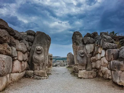
The Lion Gate, on the southwestern side of the Upper City, was named after the sculpted lions flanking its entrance. To the southeast stood the King’s Gate, decorated with a relief of an armed figure. Early archaeologists mistook the figure for a king, but its horned headgear indicates a deity. The original relief is now in the Museum of Anatolian Civilizations in Ankara, with a replica at the site.
Farther south, the Sphinx Gate stood atop Yerkapı, a massive artificial rampart faced with stone. Two stairways led to the gateway, while a 71-metre-long stone passage ran beneath it. The imposing structure may have served ceremonial as well as defensive purposes.
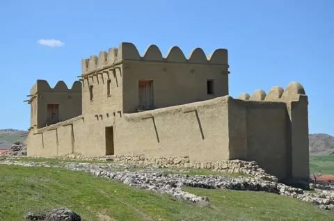
Between 2003 and 2005, the German Archaeological Institute reconstructed a 65-metre section of the city walls using traditional mudbrick techniques. Based on archaeological remains and ancient clay models, the project offers an idea of how the fortifications originally appeared and the labour required to build them.
Büyükkale: The Royal Citadel
Büyükkale, meaning “Great Fortress,” occupied a rocky plateau near the centre of Hattusa. Measuring approximately 250 by 140 metres, it overlooked both the Upper and Lower Cities. Fortified walls and a guarded entrance protected the royal complex.
Rather than a single palace, Büyükkale consisted of several buildings arranged around courtyards and connected by passageways and columned galleries. Excavations have identified a large audience hall, storage facilities, administrative rooms, and religious spaces. Cuneiform records recovered from the citadel also attest to its role in royal administration, although the exact functions of some buildings remain uncertain.
New excavations began in the upper courtyard in 2021, more than fifty years after earlier investigations ended. Research by Jörg Becker and Andreas Schachner, published in 2026, revealed that the Hittite-period buildings were more densely arranged than previously believed. Radiocarbon dates also suggest that the expansion of the royal complex began as early as the late sixteenth century BCE.
The Great Temple and Hattusa’s Religious Buildings
The Great Temple, known as Temple 1, stood in Hattusa’s Lower City. It was dedicated to the Storm God of Hatti and the Sun Goddess of Arinna, the two leading deities of the Hittite state religion.
The complex centred on a large courtyard and two inner sanctuaries believed to have housed the gods’ cult images. Surrounding buildings contained storerooms and administrative facilities. Excavations uncovered enormous pottery jars, some holding up to 2,000 litres, and cuneiform tablets in rooms along the eastern side.
Religion also shaped the Upper City. Excavations have identified 29 temple precincts, with finds including cult objects, pottery, seals, and written documents. These buildings served deities from both Hittite and Hurrian traditions, although they were not necessarily all in use at the same time.
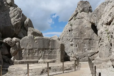
About two kilometres northeast of Hattusa stood Yazılıkaya, an open-air rock sanctuary famous for its thirteenth-century BCE reliefs. Its two natural chambers preserve some of the finest surviving examples of Hittite religious art.
In Chamber A, processions of male and female deities converge towards the Storm God Teššub and his consort Ḫepat, reflecting the influence of Hurrian religion at the Hittite court.
Chamber B contains twelve underworld gods carrying curved swords, a large sword-shaped divine figure, and a relief showing King Tudḫaliya IV embraced by his protective god Šarruma. The chamber may have been associated with royal funerary rites, although its precise function remains debated.
The Cuneiform Archives of Hattusa
Excavations at Hattusa have uncovered tens of thousands of cuneiform tablets and fragments. They came from several locations, including buildings on the royal citadel at Büyükkale, the Great Temple complex, and the House on the Slope. These were separate collections rather than a single library.
The documents include royal decrees, diplomatic correspondence, treaties, laws, administrative records, religious rituals, prayers, and myths. Many were written in Hittite, while Akkadian served as the language of international diplomacy. Other texts preserve Hattian, Hurrian, and Luwian, reflecting the linguistic diversity of the Hittite kingdom.
One of the most significant discoveries was an Akkadian cuneiform copy of the peace treaty between King Ḫattušili III and the Egyptian pharaoh Ramesses II in the thirteenth century BCE. The agreement established terms of peace, mutual assistance, and the return of fugitives between the two powers.
The tablets also reveal how Hittite scribes managed written records. Surviving catalogues and duplicate texts indicate systems for organising and preserving documents. Research on the House on the Slope has identified evidence of scribal work and the production of official and scholarly texts.
In 2001, UNESCO inscribed the Hittite cuneiform tablets from Boğazköy on its Memory of the World Register.
How Hattusa Managed Water and Food
Hattusa’s dry summers made water storage essential. The Hittites constructed reservoirs in the Upper City, including two eastern ponds with a combined capacity of approximately 36,000 cubic metres and five southern ponds holding another 20,000 cubic metres.
The reservoirs drew water from underground aquifers in the surrounding slopes. Research published in 2024 showed how groundwater accumulated during wetter months could continue feeding the ponds during summer, reducing dependence on seasonal surface streams.
Excavations in the Lower City uncovered an underground grain-storage complex measuring approximately 118 metres long and divided into 32 chambers. A fire in the early sixteenth century BCE destroyed part of the complex, preserving hundreds of tonnes of charred wheat and barley.
Further silos were discovered at Büyükkaya, where sealed underground pits allowed grain to be stored with limited exposure to air. These facilities belonged to different phases of Hattusa’s development and were not necessarily operating simultaneously.
Analysis of grain from five chambers of the Lower City complex revealed differences in growing conditions, suggesting that supplies came from multiple farming communities. Researchers have interpreted these stores as evidence of grain collected through taxation, illustrating how the Hittite administration drew agricultural resources from the surrounding countryside.
Why Was Hattusa Abandoned?
Hattusa lost its role as the Hittite imperial capital around 1200 BCE. Excavations have uncovered burned buildings, but there is little evidence that the city fell in a single violent attack. Many official buildings appear to have been emptied before the fires, suggesting that the royal administration had already departed.
The city’s decline may have begun earlier. Some districts and religious buildings were abandoned during the thirteenth century BCE, while the empire faced internal rivalries and pressure along its frontiers. No surviving evidence identifies a particular enemy or event responsible for the final departure.
Severe drought may have contributed to the crisis. A 2023 study published in Nature analysed ancient juniper tree rings from central Anatolia and identified an exceptionally dry period around 1198–1196 BCE. Three consecutive years of drought could have damaged harvests and strained food supplies, although researchers cannot establish that climate alone caused the collapse.
Hattusa’s abandonment as an imperial capital did not mean the entire site became uninhabited. Archaeologists have uncovered a small Early Iron Age settlement at Büyükkaya, showing that people continued living in the area after the Hittite royal administration disappeared.
Read Also
- Who Were the Hittites? History, Origins and Empire
— Explore the rulers, expansion, and history of the civilization governed from Hattusa. - Samuha: The Hittite Royal City and Cuneiform Archive Found in 2026
— Discover another important royal and religious centre of the Hittite kingdom. - Tarhunna: The Storm God of the Hittites
— Learn about the principal storm deity and his role in Hittite kingship and temple worship.
Rediscovery and Archaeological Excavations
Hattusa came to scholarly attention in 1834, when the French explorer Charles Texier visited the ruins near Boğazköy. He surveyed the ancient walls and monuments, including the rock reliefs at Yazılıkaya, without knowing that the site was the Hittite capital.
The first excavations took place in 1893–1894 under Ernest Chantre, who uncovered cuneiform tablets. Larger investigations began in 1906, led by Hugo Winckler and Theodor Makridi. The tablets enabled researchers to identify the ruins as Hattusa, the long-lost Hittite capital.
The discoveries also led to a breakthrough in understanding the Hittite language. In 1915, the Czech scholar Bedřich Hrozný demonstrated that Hittite belonged to the Indo-European language family. His work opened the way to translating records that had previously remained unread.
Excavations resumed in 1931 under Kurt Bittel. After an interruption during and following the Second World War, systematic work restarted in 1952 and continued under successive archaeological teams.
Hattusa was added to the UNESCO World Heritage List in 1986.
Excavations in 2024 uncovered an Old Hittite cemetery near the Upper West Gate, alongside previously unknown buildings elsewhere in the city. The cemetery provides new evidence for burial practices during the early centuries of the Hittite kingdom.
Academic Sources & Archaeological References
This article draws on archaeological excavation reports, scholarly studies of Hattusa’s urban development, research on Hittite administration and agriculture, and scientific evidence concerning the empire’s final centuries.
Archaeology and Urban Development
- Néhémie Strupler (2019).
Sacked and Cursed? New Data on the Transition from the City-State to the Hittite Capital Hattuša.
BAF-Online.
Examines Anitta’s destruction account and the archaeological evidence for the settlement’s early development. - Andreas Schachner (2024).
A New Look at an Ancient City: An Outline of the Chronological and Urban Development of the Hittite Capital Ḫattuša.
Anatolian Studies, 74, 13–46.
Reassesses Hattusa’s settlement history using archaeological stratigraphy and scientific dating. - Jörg Becker and Andreas Schachner (2026).
Boğazköy, Türkei: Ausgrabungen auf Büyükkale, dem Palastareal der hethitischen Hauptstadt Ḫattuša. Die Arbeiten der Jahre 2021 bis 2024.
e-Forschungsberichte des Deutschen Archäologischen Instituts.
Reports recent excavations of the royal citadel and revised interpretations of its architectural development. - Andreas Schachner et al. (2025).
Die Ausgrabungen in Boğazköy-Ḫattuša 2024.
Archäologischer Anzeiger.
Official excavation report covering new discoveries, including the Old Hittite cemetery near the Upper West Gate.
Water, Agriculture and Environmental Research
- Hartmut Wittenberg and Hafzullah Aksoy (2024).
Filling the Ponds of Hattuşa: A Geohydrological Approach to Determine Inflows by Time and Volume.
Environmental Earth Sciences, 83, Article 478.
Explains how groundwater supplied the capital’s reservoirs during dry seasons. - Charlotte Diffey, Reinder Neef, Jürgen Seeher and Amy Bogaard (2020).
The Agroecology of an Early State: New Results from Hattusha.
Antiquity, 94(377), 1204–1223.
Analyses grain recovered from Hattusa’s storage complex and its implications for agricultural production and taxation. - Sturt W. Manning et al. (2023).
Severe Multi-Year Drought Coincident with Hittite Collapse around 1198–1196 BC.
Nature, 614, 719–724.
Presents tree-ring evidence for severe drought near the empire’s collapse without establishing climate as its sole cause.
Archaeological Heritage and Written Records
- UNESCO World Heritage Centre.
Hattusha: The Hittite Capital.
Official documentation of the archaeological site, including its urban layout, fortifications, royal buildings, temples, and Yazılıkaya sanctuary. - Turkish National Commission for UNESCO.
The Hittite Cuneiform Tablets from Boğazköy.
Documentation of the tablet collection inscribed on UNESCO’s Memory of the World Register in 2001.
Research note: Hattusa’s buildings developed across different periods, and the causes of its abandonment remain debated. Archaeological findings, ancient written records, and environmental evidence must be interpreted together rather than treated as proof of a single historical explanation.
Copyright & Content Rights
© 2026 History & Myths. Written by H. Moses. All rights reserved. Unauthorized reproduction or republication of the original article is prohibited. Brief quotations for research, education, or commentary should include proper attribution and a link to the original article. Images and third-party materials remain subject to their respective credits and licenses.